
Thursday, March 29, 2012
3/29/2012
Today was pretty much identical to yesterday with similar temperatures and the wind never really died down either. It is currently 48°F with winds from the ESE at 21 mph. The barometric pressure is holding around 29.91in. It appears that some much needed rain is on the way as precipitation is likely overnight and also through the morning. Friday will bring cooler weather but warmer air will arrive in the area over the weekend. The jet stream shows that our area is currently towards the upper part of a ridge which means we are positioned in an area of cooler air whereas the areas to our south are in areas of warmer weather. Remember, the jet stream acts as a divider between air masses.

Wednesday, March 28, 2012
3/28/2012
Overall, today was not too shabby weather wise. The winds calmed down but were still noticeable, the sun was shining most of the day as the sky was partially dotted with some upper level clouds. It is currently 40°F with winds out of the ENE at 7 mph. Temperatures are expected to drop to below freezing during the overnight and will climb back into the mid 50s with clouds occupying most of the sky. A frost advisory is in effect for the area and with the warm temperatures lately, many of the plants and flowers have started to bloom which means they are endangered by the freezing temperature forecasted tonight. With winds out of this direction, coupled with the fact there were cumulostratus clouds in the sky, precipitation will be likely within the next 30 hours and that is what we should expect tomorrow.
Tuesday, March 27, 2012
2/27/2012
The temperature warmed up quite nicely today but was coupled with a very breezy day. Temperatures reached the mid 70s but the wind gusted up to 40 mph. The strong low pressure system from the Dakotas has seemed to have moved past us, at least the major part of it. Partly cloudy skies lingered around all day and then the cloud pattern started to break apart in such a pattern that one could tell a new front or air mass was moving in. It appears a cold front is moving into the area which will bring cooler temps for the next few days with a possible shower on Thursday. It has been very dry in the area so we could use a good dousing which is unlikely for the near future. The surface data map clearly shows a large area of low pressure centered in the Midwest with winds blowing in a counterclockwise pattern and also cloudy skies in much of the image.

Monday, March 26, 2012
3/26/2011
I am back from spring break and what a difference a week makes in weather. After record high temperatures were witnessed pretty much every day last week, our region has succumbed to a chilly period. While the cool temperatures won't stick around long it is really quite the drastic change. Right now the temperature is at 41°F with winds from the SE at 12 mph. The good news is that warmer temps are on their way with a wind from the South and also a major low pressure system moving in from the Dakotas will bring strong winds tomorrow as well. The warm front could bring possible precipitation with it as well but is not likely. The rest of the week though will be in the 50s or low 60s but then back into the 70s by the weekend.
Thursday, March 15, 2012
3/15/2012
We got close to setting another record high today as the temperature reached 64.9°F with clear skies for most of the day. I read somewhere that over 1000 record temperatures were recorded in the U.S. this week! Right now winds are 5 mph from the north and the sky to the north contains a few high whispy cirrus clouds while the sky to the south and southwest contain stratus and stratocumulus clouds. Skies may cloud up some more as the weak low pressure system moves through the area. No precipitation is likely to occur from it however. Warmer temps are headed our way tomorrow and into next week.
| Cloud Cover |
Wednesday, March 14, 2012
3/14/2012
Today's temperature smashed the record as we reached a high of 74°F and the record had been 66°F. For the most part the skies were clear with a few cirrus clouds in sight. As the day drug on, some cumulostratus clouds took over about 50% of they sky. The wind is out of the east at 3 mph. A cold front is moving through but not significant enough to make it feel cold again. Temperatures are expected to be in the mid 60s still and we will probably see a stable atmosphere and mostly sunny skies. The temps jump back into the 70s on Friday and continue into the next week!
Tuesday, March 13, 2012
3/13/2012
1

Another perfect warm day in early March! Temperatures climbed into the mid 60s today as warm weather continued to be blown northwards as the winds were from the south again today. The barometric pressure trend has risen considerably over the course of 24 hours as is noted by the high pressure system sitting between WI and MI. There is a weird shift of winds around southern WI and IL which is most likely from a warm air mass and cold air mass colliding in that area. Different pressure systems lead to different wind patterns as winds blow in a clockwise position around a high pressure system and counterclockwise around a low pressure system. The skies were mostly clear today with high level cirrus clouds through most of the sky which is generally a sign of fair weather.
Monday, March 12, 2012
3/12/2012
Woke up to rain this morning as the storm front from the SW made its way through the area. After the storm the sky was covered in cumulostratus clouds which slowly broke apart and gave way to a little bit of sunlight this afternoon. The winds switched to the WSW and now they are again blowing from the SW which means warmer weather is on its way! The sky is still overcast and pressure has gone back up slowly as the low pressure system has moved out. It is pretty humid (86%) out after the rain so there is a lot of available moisture in the air. A high pressure system will be settling in which means clear skies and a stable atmosphere. Record temperatures are in jeopardy this week.
Sunday, March 11, 2012
3/11/2012
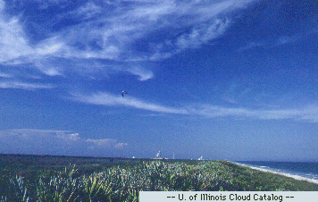
1:00 p.m - Another day of beautiful spring weather! The current temperature is 62° F with winds out of the SSW at 10 mph gusting up to 20 mph. The cloud cover right now is 50% dominated with cirrus clouds and a few small cumulus clouds. Expect clouds to increase throughout the day as a storm system is expected in our area by the end of the evening and rain is likely overnight into the a.m. when it should clear up. The storm cell currently in the South is being pushed up our way by the strong winds from the SSW.
6:30 p.m. - The sky has been taken over by a mass of ominous looking altostratus clouds which often indicate precipitation within 12 hours. The temperature has dropped to 60°F and the barometric pressure is dropping. Looking at the map below, it looks like a low pressure system is heading into the area bringing precipitation with it.
6:30 p.m. - The sky has been taken over by a mass of ominous looking altostratus clouds which often indicate precipitation within 12 hours. The temperature has dropped to 60°F and the barometric pressure is dropping. Looking at the map below, it looks like a low pressure system is heading into the area bringing precipitation with it.
Saturday, March 10, 2012
3/10/2012
Today was the warmest day of the year so far as temperatures crawled into the 60's. We had some strong southwest winds blowing warm air into the area. For most of the day the sky was 6/10 covered in cirrus fibratus clouds which generally indicate fair weather. It is currently 58° F with winds out of the SW still at 10 mph. We can expect to see another warm day tomorrow then a strong chance of rain on Monday.
Tuesday, March 6, 2012
3/6/2012
The temperature is starting to rise pretty fast today already as we are expected a high of 50°F. This mornings temperature was 28° with scattered skies. The main cloud types looked like high level clouds as in cirrus mostly in the east and also some altostratus clouds in the south. The winds are SSE at 14 mph which is pushing all this warm weather to us. The jet stream is staying above us towards the north which will allow for some warmer weather for the region. There was some shearing in the clouds which represent a different air mass entering the region. Rain is expected tomorrow as a cold front will pass through.
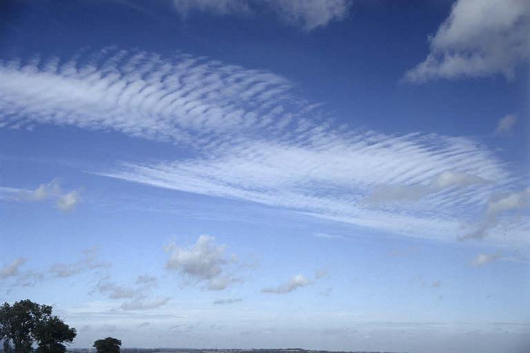 |
| Altostratus |
 |
| Cirrus |
| Current Conditions |
Monday, March 5, 2012
3/5/2012
Today remained somewhat cold but not as bad as yesterday. We even got some flurries for a 2 hour period this afternoon which was unexpected. I noticed after the "storm" passed the clouds started to disperse as stratus clouds took over the skies. Right now we have clear skies and winds from the South at 12 mph. This is a major reason we are expected to be in the 50s tomorrow!! We have this gorgeous looking warm front heading our way which is leaving some precipitation in LA, AR, MO, and IA. The low pressure system explains the strong winds we are getting.
Sunday, March 4, 2012
3/4/2012
Right now it is 19°F with partly cloudy skies and no winds. We had some lingering snowflakes today as highs reached 30° which is below the average. The barometric pressure has moved back up to 29.03 inches and it looks like the week ahead will be very spring-like. Southerly winds will push some warmer air into the area and possibly a little rain on Wednesday. Here is a map showing current conditions around the country. There are still some storms hitting the areas devastated by tornadoes this past week as cold air and warm air are mixing right over the area.
Saturday, March 3, 2012
3/3/2012
It was much cooler today than it has been in some time. It is currently 25°F with winds out of the west @ 8 mph. The dew point is sitting at 17° and the barometric pressure is 28.79 in.. We had flurries flying around pretty much all day with cloudy skies to boot. There is a cold front from Canada that descended upon us today which is why it was so cold. There is not much activity except in the SE where it looks like some good precipitation going on as a cold front passes over a small warm front and low pressure system. More big and deadly storms in the states directly below us especially in KY and IN. There were around 38 fatalities and the same region is now expecting snow or even more tornadoes.
There are some strong winds coming from the West but other than that it seems pretty calm all around the country.

There are some strong winds coming from the West but other than that it seems pretty calm all around the country.
Friday, March 2, 2012
3/2/2012
We are currently at 37.9°F with 100% cloud cover(looks like stratus clouds), pressure @ 28.61 inches, and a dew point of 28°. There is a very large storm system hovering around a strong low pressure system in southern WI, IL, MI, IN, and OH. It looks like some warm moist air coming from a maritime tropical air mass in the South has hit a cold air mass from a continental polar air mass from the North. From this system may come some more strong tornadoes which will be focused in IN, OH, KY, and TN. Here is a map of current weather watches and warnings for today(Yellow is tornado, blue=snow, pink/purple=sleet).

This winds map shows where the strength of the low pressure system is located and those are the areas that should expect the strongest of the storms.
This map illustrates cloud temperatures. Cloud formations happen in areas of unstable air and the higher the cloud, the colder it is and so looking at the temperature bar on the bottom we see that the bright yellow and orange areas indicate cold clouds. These clouds will be forming ice crystals and so these areas are likely to experience some sleet or cold rain depending on the surface temperatures. I think that the relatively warmer temperatures as of late have caused a lot of surface evaporation and are fueling these large spring storm cells.
Thursday, March 1, 2012
3/1/2012
It is currently 41.2°F with overcast skies and a dew point of 37° with winds out of the south @ 5 mph. It appears that there is some sort of precipitation close to our area as a cold front from a continental polar air mass, enters an area of low pressure. The predictions only give us a slight chance of precipitation through the overnight with up to an inch possible. This is just a weak system and the front coming up from the South will most likely miss us. Here is the current radar.

Subscribe to:
Posts (Atom)